Moss in a forest scene

Community Odour
Monitoring Program

2018 Annual Report

Cody David

About

The WBEA’s Community Odour Monitoring
Program (COMP)

The Wood Buffalo Environmental Association (WBEA) monitors the air quality in the Regional Municipality of Wood Buffalo (RMWB) 24 hours a day, 365 days a year, through a network of 28 ambient air monitoring stations. Each station contains multiple analyzers that continuously measure the concentration of different pollutants, along with meteorological parameters such as wind speed, wind direction, temperature, humidity, and atmospheric pressure.

The WBEA was repeatedly approached by members of different communities in the RMWB about the odours they experienced. Currently, analyzers can measure the concentration of specific pollutants or groups of pollutants, but it cannot measure if an odour is present or how strong an odour would be.

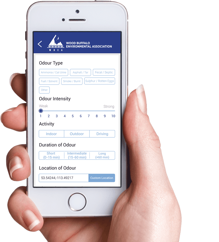
The WBEA created an app which allows people to directly provide information about the odours they experience. The app allows the WBEA to connect the information people provide about odours, to the ambient air data being collected at WBEA air monitoring stations.

The app was officially launched in September 2017. This first Annual Report covers the period of September 2017 to December 2018. Future reports will be released for each calendar year.

COMP APP Information

Below is an explanation of the information collected in the app and then used by the WBEA to compare with the ambient air data collected at each station. The WBEA wants to develop an understanding of the odours people are experiencing and has provided categories for users to describe their experience.

Odour Type

Once an odour is at a concentration high enough to be detected by an individual, the type of odour can be described. The odour type is completely subjective based on the person, and within the COMP app there are currently seven options: Ammonia/Cat Urine, Asphalt/Tar, Fecal/Septic, Fuel/Solvent, Smoke/Burnt, Sulphur/Rotten Eggs, and Other. Users are to select the odour type that best describes, to them, the odour they are experiencing.

Odour Intensity

The intensity of an odour is the perceived strength of the odour that is being experienced by the individual and is not necessarily related to its concentration. For example, a particularly pungent odour at a low concentration may be perceived to be more intense than a less pungent substance at a higher concentration. The intensity may also depend on the individual’s sensitivity to odours.

Activity

Activity is included so that users can provide information about what they are doing when they encounter the odour; they can indicate whether they are indoors, outdoors, or driving.

Duration of Odour

Duration of odour is the length of time the user experiences the odour. This is to provide context about whether someone had a brief encounter with an odour, or experienced a long-lasting, persistent smell.

Location of Odour

It is necessary to collect the position where the user experienced the odour so that the WBEA can compare the data to the closest ambient air monitoring station. It is also used to compare multiple observations to each other if they are submitted from the same area.

Time Odour Detected

To compare odours experienced by users to the data the WBEA collects at their ambient air monitoring stations, the WBEA needs to know the date and time the user encountered the odour.

Energy & Environmental Response Reference Number (Optional)

If an odour is particularly strong and a user wants to file a report with the Alberta Government, they can call their 24-hour Energy & Environmental Response line, whose number is listed on the main page of the app. When a user files a report, they will be provided with a Reference Number. The user can enter that Reference Number in to the app, to show a report was filed. It is an optional field.

phone with the COMP app open on it
layered blue background graphic

About Odours

Some humans have a sensitive sense of smell and can detect odours even when chemicals are present in very low concentrations. Most odours that occur in ambient air (i.e., outdoor air that is not on an industrial site) are caused by very small traces of chemicals. The ability to smell a particular odour varies from person to person due to variations in their sensitivity and depends on the concentration of the pollutant.

Meteorology and Odours

Atmospheric conditions and weather can affect pollutants that have been released into the air. As an air pollutant, which may or may not have an odour, is transported from the source from which it was emitted to a community, the pollutant mixes into the surrounding air so that it arrives at a much lower concentration than it was when it initially emitted. The concentration of an air pollutant that reaches a community is due to many variables, including the amount of the pollutant released at the source, the height of the source, the distance from the source to the community, the surrounding topography, and local weather conditions. The most important weather influences are wind speed, wind direction, precipitation, sunlight, and the amount of turbulence in the atmosphere. Generally, strong winds disperse pollutants, whereas light winds can allow pollutants to build up over an area. The wind direction determines where emissions are transported.
Odour Causing Compounds

Hydrogen Sulphide & Total Reduced Sulphur Compounds

Total Reduced Sulphurs (TRS) are a large group of sulphur-containing compounds, including hydrogen sulphide (H2S) and mercaptans. Many TRS compounds can produce offensive odours at low concentrations. Due to the sulphur, TRS compounds tend to have a smell similar to rotten eggs. Concentrations of H2S and TRS are measured in parts per billion (ppb).

Non-Methane Hydrocarbons (NMHC)

Hydrocarbons are a large group of compounds, which are either measured as total hydrocarbons (THC), or due to new monitoring technology, can be split into methane (a single carbon atom = C1) and non-methane hydrocarbons (the sum of all C2 to C12 hydrocarbon compounds). Methane itself does not have an odour – a smelly chemical is usually added to methane to allow you to smell it when you are using Natural Gas. Methane from industrial combustion does not have the additive, so will not have an odour. Methane is also present naturally in the air, at a concentration of about 1.8 parts per million (ppm).

However, many other hydrocarbons besides methane, called the “non-methane hydrocarbon” (NMHC) portion, may have odours and may have them at very low concentrations. Depending on the substance, they may smell like rotten cabbage, smelly socks, or eggs. Concentrations of NMHC are measured in parts per million (ppm).

Sulphur Dioxide (SO2)

The WBEA monitors sulphur dioxide (SO2) due to sulphur emissions from the oil sands industry. SO2 is emitted when fuel containing sulphur is combusted. Generally, concentrations of SO2 are not high enough for people to smell it. However, we use ambient air concentrations of SO2 to indicate the potential presence of an industrial plume. That industrial plume may contain other, more odorous compounds which may be the cause of the odours people are experiencing. This can help distinguish the industrial odours from other local sources like construction, road work, and sewage plants. Concentrations of SO2 are measured in parts per billion (ppb).

WBEA Air Monitoring Stations Map

Air Monitoring Stations These are all the Air Monitoring Stations the WBEA operates

Community Air Monitoring Stations The Community Air Monitoring Stations are the stations the WBEA operates within the communities of the RMWB. The WBEA used the data from community stations to compare to the submitted COMP odour observations.

Drone view of wetlands

Overview
of 2017-2018

Cody David

Summary of COMP Observations

The graphs below show a breakdown of all the odour observations received between September 2017 and December 2018, by criteria such as odour type, odour location, time of day, etc. When you hover over the bar, the exact number of odour observations in each category will pop up.

Purple textured background

Community Breakdown

This section provides the breakdown of odour observations received in each community within the Regional Municipality of Wood Buffalo. The map shows the location of all the observations received between September 2017-December 2018. The histograms show the distribution of the number of observations received at different ambient concentrations of the pollutants of interest. Interestingly, most observations are submitted when ambient concentrations are low.

The last part of the Community Breakdown is the pollution and wind roses. A description of the graph is provided below; they’re used to show the prevailing wind direction (wind rose) when observations were submitted, and the prevailing wind direction plus ambient concentration of pollutants (pollution rose) when observations were submitted.

Community

Anzac

From September 2017-December 2018, 4 observations were received from Anzac.

  • Ammonia map icon

    Ammonia

  • Asphalt map icon

    Asphalt

  • Fecal map icon

    Fecal

  • Fuel map icon

    Fuel

  • Smoke map icon

    Smoke

  • Sulphur map icon

    Sulphur

  • Other map icon

    Other

  • Community air monitoring station map icon

    Community Air Monitoring Station

The following histograms show the distribution of different air quality and meteorological parameters. This is not representative of the whole year, but rather only shows the conditions when odours observations were submitted through the COMP app between September 2017-December 2018.

Conklin

From September 2017-December 2018, 4 observations were received from Conklin.

  • Ammonia map icon

    Ammonia

  • Asphalt map icon

    Asphalt

  • Fecal map icon

    Fecal

  • Fuel map icon

    Fuel

  • Smoke map icon

    Smoke

  • Sulphur map icon

    Sulphur

  • Other map icon

    Other

  • Community air monitoring station map icon

    Community Air Monitoring Station

The following histograms show the distribution of different air quality and meteorological parameters. This is not representative of the whole year, but rather only shows the conditions when odours observations were submitted through the COMP app between September 2017-December 2018.

Fort Chipewyan

There is no data from this community!

If you are experiencing odours in your community and want to participate in COMP, download our app by searching "WBEA" on the Apple App store or the Google Play store. Your observations will be included in next year's report.

  • Ammonia map icon

    Ammonia

  • Asphalt map icon

    Asphalt

  • Fecal map icon

    Fecal

  • Fuel map icon

    Fuel

  • Smoke map icon

    Smoke

  • Sulphur map icon

    Sulphur

  • Other map icon

    Other

  • Community air monitoring station map icon

    Community Air Monitoring Station

Fort McKay

From September 2017-December 2018, 33 observations were received from Fort McKay.

  • Ammonia map icon

    Ammonia

  • Asphalt map icon

    Asphalt

  • Fecal map icon

    Fecal

  • Fuel map icon

    Fuel

  • Smoke map icon

    Smoke

  • Sulphur map icon

    Sulphur

  • Other map icon

    Other

  • Community air monitoring station map icon

    Community Air Monitoring Station

The following histograms show the distribution of different air quality and meteorological parameters. This is not representative of the whole year, but rather only shows the conditions when odours observations were submitted through the COMP app between September 2017-December 2018.

Fort McMurray

From September 2017-December 2018, 219 observations were received from Fort McMurray.

  • Ammonia map icon

    Ammonia

  • Asphalt map icon

    Asphalt

  • Fecal map icon

    Fecal

  • Fuel map icon

    Fuel

  • Smoke map icon

    Smoke

  • Sulphur map icon

    Sulphur

  • Other map icon

    Other

  • Community air monitoring station map icon

    Community Air Monitoring Station

The following histograms show the distribution of different air quality and meteorological parameters. This is not representative of the whole year, but rather only shows the conditions when odours observations were submitted through the COMP app between September 2017-December 2018.

Highway 63 North

From September 2017-December 2018, 113 observations were received from Along Highway 63 North.

  • Ammonia map icon

    Ammonia

  • Asphalt map icon

    Asphalt

  • Fecal map icon

    Fecal

  • Fuel map icon

    Fuel

  • Smoke map icon

    Smoke

  • Sulphur map icon

    Sulphur

  • Other map icon

    Other

  • Community air monitoring station map icon

    Community Air Monitoring Station

The following histograms show the distribution of different air quality and meteorological parameters. This is not representative of the whole year, but rather only shows the conditions when odours observations were submitted through the COMP app between September 2017-December 2018.

Janvier

From September 2017-December 2018, 3 observations were received from Janvier.

  • Ammonia map icon

    Ammonia

  • Asphalt map icon

    Asphalt

  • Fecal map icon

    Fecal

  • Fuel map icon

    Fuel

  • Smoke map icon

    Smoke

  • Sulphur map icon

    Sulphur

  • Other map icon

    Other

  • Community air monitoring station map icon

    Community Air Monitoring Station

The following histograms show the distribution of different air quality and meteorological parameters. This is not representative of the whole year, but rather only shows the conditions when odours observations were submitted through the COMP app between September 2017-December 2018.
Blue textured background

Odour Event Days

Odour event days were days that had six observations submitted, with at least four of them being from the same geographical location. There were eight days that met these criteria; seven in Fort McMurray and one in Fort McKay. Below, each date is presented along with the ambient air monitoring data from the nearest ambient air monitoring stations.

Event Day

October 29, 2018 - Fort McMurray

On October 29, 2018, seven odour observations were submitted; four from the Timberlea area, two from the Dickensfield area and one from Thickwood Heights. Three of the observations reported the Odour Type as ‘Asphalt’, while two were reported as ‘Fuel’, one as ‘Sulphur’ and one as ‘Smoke’.

The air monitoring station (AMS) closest to the uptown areas is Patricia McInnes AMS by the Syncrude Athletic Park in Timberlea. The downtown air monitoring station is Athabasca Valley AMS which is located by the Athabasca River on the road to MacDonald Island.

All the observations were submitted between the hours of 06:00 and 09:00. TRS concentrations increased from 0.5 to 1.5 ppb at both sites during this period. SO2 showed little change during the time period but NMHC levels at both sites increased, peaking at around 0.5 ppm at 09:00.

Winds were from the north-northwest for the entire day with wind speeds light during the morning but increasing later in the day.

Conclusion: The large increase of NMHC measured at Patricia McInnes AMS was likely responsible for the odours being experienced in the area. The lack of an increase in SO2 during the observation period may indicate that the odours were from a non-industrial source.

July 17, 2018 - Fort McMurray

On July 17, 2018, four odour observations were submitted, all from the Timberlea area. One of the observations was reported at 06:00 with an Odour Type of ‘Asphalt’ and the other three were reported at 22:00 with two observations as ‘Asphalt’ and one as ‘Fuel’.

The air monitoring station (AMS) in Timberlea is Patricia McInnes AMS by the Syncrude Athletic Park. The next closest air monitoring station is Athabasca Valley AMS, which is located downtown by the Athabasca River on the road to MacDonald Island.

Both TRS and NMHC concentrations were at background levels during the entire period at both air monitoring sites. At Athabasca Valley, beginning at 10:00, SO2 concentrations increased from near zero to peak at over 40 ppb at 11:00 but this did not correspond to the odour observations. There was no comparable increase in SO2 at the AMS 6 site.

Wind directions were variable during the day and the wind roses for each site were quite different.

Conclusion: There were no increases in any of the measured parameters at the time of the reports. The odours may have been due to localized conditions, in the areas the observations were submitted from, that did not reach the air monitoring station, or were caused by compounds not measured at the air monitoring stations.

June 19, 2018 - Fort McMcKay

On June 19, 2018, five odour observations were submitted, all from the Fort McKay area. Three of the observations reported the Odour Type as ‘Sulphur’ with one was reported as ‘Fuel’ and one as ‘Asphalt’.

There are two air monitoring stations (AMS) in Fort McKay. Bertha Ganter-Fort McKay AMS is located near the northwest corner of the Fort McKay Water Treatment Plant and measures TRS, SO2, and NMHC. The Waskow ochi Pimatisiwin AMS is in the Environment and Climate Change Canada Oski-Otin compound in Fort McKay and measures H2S and SO2.

All but one of the observations were submitted during the hours of 08:00 and 09:00 with the other observation at 20:00. TRS and H2S concentrations were very low (< 1.5 ppb) during the entire period but did reach a maximum of 0.9 ppb at both sites at 09:00. NMHC peaked at Bertha Ganter-Fort McKay AMS at the same time and reached 0.6 ppm. NMHC also increased at 20:00 at Bertha Ganter-Fort McKay AMS. Although SO2 concentrations were very low (less than 1.5 ppb) they did peak at both sites during the time of the observations.

Winds were predominantly from the southwest for the day, however, for the period of 06:00 - 10:00 they were from the south-southeast with speeds of less than 10 km/h.

Conclusion: TRS, H2S, and SO2 concentrations were very low during the entire period but did reach their maximum at the time when three of the observations were reported, which could potentially indicate an industrial plume in the region. The large increase of NMHC concentrations (0.6 ppm) corresponded with the times of the observations and was likely responsible for the odours experienced in the community.

June 10, 2018 - Fort McMurray

On June 10, 2018, seven odour observations were submitted; five from the Timberlea area and two from the Dickensfield area. Six of the observations reported the Odour Type as ‘Asphalt’ and one was reported as ‘Fuel’.

The air monitoring station (AMS) closest to both Dickensfield and Timberlea is Patricia McInnes AMS by the Syncrude Athletic Park in Timberlea. The next closest air monitoring station is Athabasca Valley AMS, which is downtown by the Athabasca River on the road to MacDonald Island.

All but one of the observations were submitted during the hours of 14:00 and 15:00 with the other observation at 21:00. TRS concentrations were very low during the entire period but did reach a maximum of 0.9 ppb at AMS 6 at 15:00. NMHC concentrations peaked at Athabasca Valley at the same time going from 0 to 0.4 ppm but showed little change at AMS 6. Although SO2 concentrations were very low (less than 4 ppb) they did increase at Patricia McInnes AMS during the time of the observations.

Winds were predominantly from the north and north-northwest for the day with wind speeds of 12 to 20 km/h for the afternoon and evening hours.

Conclusion: TRS concentrations were less than 1 ppb at both sites but the peak concentration corresponded with the observations at Patricia McInnes AMS. A large increase in NMHC was observed at Athabasca Valley AMS corresponding to the 14:00-15:00 observations but no increase was observed at the Patrician McInnes AMS, which is the station closest to the observations. It is possible the people who submitted the observations were sensitive to the very small increases in TRS and NMHC, or that the odours were due to localized conditions, in the areas the observations were submitted from, that did not reach the air monitoring station.

March 29, 2018 - Fort McMurray

On March 29, 2018, five odour observations were submitted, all from the Timberlea area. One of the observations was reported at 04:00 with an Odour Type of ‘Ammonia’, three were reported between 10:00 and 12:00 with two observations as ‘Sulphur’ and one as ‘Fuel’ and the final observation was reported at 23:00 as ‘Fecal’.

The air monitoring station (AMS) in Timberlea is Patricia McInnes AMS by the Syncrude Athletic Park. The next closest air monitoring station is Athabasca Valley AMS, which is downtown by the Athabasca River on the road to MacDonald Island.

Both TRS and NMHC concentrations were at background levels during the entire period at both air monitoring sites. At AMS 6, beginning at 08:00, SO2 concentrations increased from near zero to peak at over 30 ppb between 10:00 and 11:00.

Winds were predominantly from the north-northwest for the day with light wind speeds (5 - 7 km/h).

Conclusion: The odour parameters (TRS and NMHC) were near or below background. Light winds were blowing from the North for most of the day. The peak in concentrations of SO2 did coincide with observations of odours, so SO2 was potentially an indicator of an industrial plume which could be carrying other odour-causing compounds.

January 20, 2018 - Fort McMurray

On January 20, 2018, twelve odour observations were submitted; eight from the Timberlea area, two from the Thickwood area, one from downtown and one from Gregoire. Four of the observations reported the Odour Type as ‘Asphalt’, three reported ‘Fuel’, two reported ‘Sulphur’, one ‘Smoke’ and two as ‘Other’.

The air monitoring station (AMS) closest to both Timberlea and Thickwood is Patricia McInnes AMS by the Syncrude Athletic Park in Timberlea. The closest air monitoring station to downtown and Gregoire is Athabasca Valley AMS, which is located downtown by the Athabasca River on the road to MacDonald Island.

In Timberlea and Thickwood, two observations were submitted in the morning between 07:00-08:00, six during the hours of 18:00, and the last two during the hour of 20:00. Both the downtown and Gregoire observation were also submitted during the hour of 18:00.

Patricia McInnes AMS showed a spike in SO2 concentrations (maximum of 17 ppb) at the time of the morning observations and a small increase in TRS. There was a large spike in NMHC concentrations (from 0 to 0.7 ppm) at the time of the evening observations from 17:00 to after 20:00, and TRS concentrations also spiked and reached a maximum of 3.3 ppb at 19:00.

Air pollution levels were very low at the Athabasca Valley AMS for the entire day with no peaks in concentrations that corresponded with any of the submitted odour observations.

Winds were predominantly from the north-northwest for the day with light wind speeds of less than 5 km/h in the morning and increasing to 12 km/h by 20:00.

Conclusion: The peak of SO2 in the morning was potentially an indicator of an industrial plume carrying other odour causing compounds that were responsible for the odours experienced in the morning. The large spike in NMHC and moderate increase in TRS in the evening was likely responsible for the odours experienced throughout the city in the evening. There was no corresponding increase in NMHC & TRS concentrations at the downtown Athabasca Valley AMS, even though odour observations were submitted from those areas at the same times. This may indicate the presence of other odour-causing compounds, or that the odours being experienced in downtown and Gregoire may have been due to local odour sources.

October 29, 2017 - Fort McMurray

On October 29, 2017, six odour observations were submitted; three from the Timberlea area, and three from the Dickensfield area. Four of the observations reported the Odour Type as ‘Asphalt’, one as ‘Fuel’, and one as ‘Fecal’.

The air monitoring station (AMS) closest to both Dickensfield and Timberlea is Patricia McInnes AMS by the Syncrude Athletic Park in Timberlea. The next closest air monitoring station is Athabasca Valley AMS, which is downtown by the Athabasca River on the road to MacDonald Island.

The three observations from the Dickensfield area were all submitted during the hour of 13:00. The Timberlea observations were submitted between 12:00 and 17:00. Both TRS and NMHC concentrations were at background levels during the entire period. Although SO2 concentrations were very low (less than 4 ppb) they did increase during the time of the observations.

Air pollution levels were very similar at the Athabasca Valley monitoring site with SO2 showing a similar small peak (less than 4 ppb) during the period of observations.

Winds were predominantly from the north for the day with wind speeds over 20 km/h.

Conclusion: The odour parameters (TRS and NMHC) were near or below background levels. Moderate winds were blowing from the North for most of the day. The peaks in concentrations of SO2—although at very low levels—did coincide with observations of odours, so SO2 was potentially an indicator of an industrial plume which could be carrying other odour-causing compounds. The odours could also have been due to localized conditions, in the areas the observations were submitted from, that did not reach the air monitoring station.

October 22, 2017 - Fort McMurray

On October 22, 2017, seven odour observations were submitted; four from the Dickensfield area and three from the downtown area. Five of the observations reported the Odour Type as ‘Asphalt’, while one was reported as ‘Ammonia’, and one as ‘Fuel’.

The air monitoring station (AMS) closest to Dickensfield is Patricia McInnes AMS by the Syncrude Athletic Park in Timberlea, while the downtown air monitoring station is Athabasca Valley AMS which is located by the Athabasca River on the road to MacDonald Island.

All three odour observations from downtown were submitted between 11:00-13:00. NMHC concentrations were low but above background at Athabasca Valley for most of the period, with an additional increase at the time of the observations. There was also an increase in SO2 from 2 to 10 ppb after the observations were submitted. TRS concentrations remained above background for most of the day reaching a peak of 2 ppb.

Of the four observations from the Dickensfield area, three were submitted during the hour of 16:00, and one during the hour of 18:00. NMHC concentrations were low at Patricia McInnes but did increase at the time of the observations and corresponded with an increase in concentrations of SO2 from 2 to 14 ppb. TRS concentrations remained above background for most of the day reaching a peak of 2 ppb.

Winds were from the north and north northwest for the day with wind speeds ranging from 5 to 12 km/h.

Conclusion: All measured parameters (TRS, NMHC and SO2) were above background but still at relatively low concentration levels. Light to moderate winds were blowing from the North for most of the day. The peaks in concentrations of NMHC and SO2 did coincide with observations of odours and even though those compounds were likely not directly responsible for the odours people were experiencing they potentially indicate an industrial plume which could be carrying other odour-causing compounds.

WBEA app modelled on a phone

Comp still needs YOU!

The Community Odour Monitoring Program is still going on. To participate and provide information on the odours you experience in the Regional Municipality of Wood Buffalo:

1

Download our COMP app at wbea.org/apps, or by searching WBEA on the Apple App store or the Google Play store

2

When you smell an odour in the air, submit an observation in the app

The information collected is anonymous and will be used for research purposes only.